PRECISION FARMING
A New Age Farming Tool
The changing global economic environment is going to mean that farmers are going to have to change their approach to how they manage their businesses. The tractor revolutionized farming across the world. Today, the use of data is having a very similar effect. With cultivatable land in decline and ever-increasing demand for food, farmers who use data can turn ordinary harvests into bumper crops and profits. Precision agriculture is a method in which farmers optimized inputs such as water and fertilizer to enhance productivity, quality, and yield. It also involves minimizing pests and diseases through spatially targeted application of precise amount of pesticides. Precision farming is a farming management concept based on observing and responding to in travail variations. Geospatial science has a major role to play in securing both food and nutritional security in agricultural systems, technologies like satellite imagery, GPS information technology and other geospatial tools.
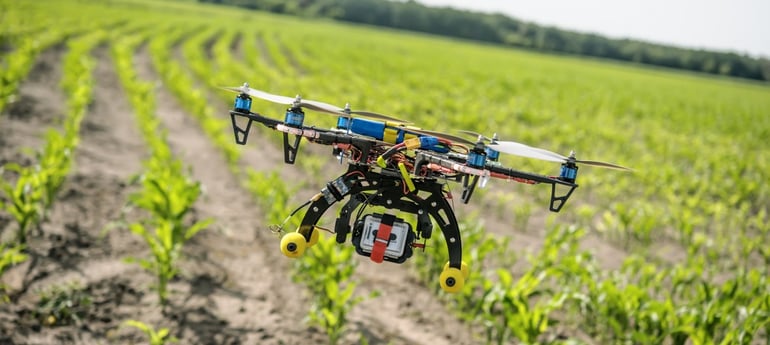
Observing variability in crops are the first steps of precision agriculture process. Sensors in the field, measure the moisture content and temperature of the soil and surrounding air. Satellites and robotic drones provide farmers with real-time images of individual plants. Information from those images can be processed and integrated with sensors and other data to guide for immediate and future decisions such as precisely which fields to water and when or where to plant a crop. For example, it can give an idea if the need to apply a mineral or fertilizer in one area of the land rather than using it in the entire farm, thus saving money, resources and time. Unmanned aerial vehicles (UAVs) allow farmers to monitor crop and livestock conditions consistently by air to find problems that would not be visible in ground level spot checks and an example a farmer can inspect whether his crop is not being properly irrigated through time-lapse.
How to integrate those management practices into farms? Some of it takes place on the nitrogen side of things.A majority of the nitrogen that gets applied is as a side dress. It is by planning all the fields using variable rate technology owing to the variability throughout the fields – areas with high organic matter, low organic matter, sand, or clay. It starts with writing a variable rate prescription while planting the crop and further transforming them into prescriptions for nitrogen application which is mimicking the seeding rate. In other words, applying less nitrogen in areas with less seeds and vice-versa. This promotes increase in nitrogen use efficiency and returning a higher yield.
The major challenge is getting costs under control and farming better. Look at Chimney pot farm in the county of Suffolk, England. It is a mixed farm, it's about 650 hectares and have a mixture of cereals and sheep. In the old days you'd go into a field and you do your W pattern and take a good walk through your field, but that's just a thing of the past because with the drone you can walk every single square meter of the field. If John wants to look in detail at one of his fields he would do that with the drone, John uses the satellite imagery to look at overall crop health and to uses his drone for flying and looking in detail how the crops are performing. Crop-scan is the box on the side of the harvester which takes a sample every 10 seconds. It allows to segregate different qualities not just in the grains but in the field on a load by load basis that enables us to add value to the sales. The right technology makes sure that it is consistently successful throughout the system, which is a seed drill for sowing seeds to build fertility successfully on the farm which is the keystone of the successful organic rotation.
Precision agriculture requires collecting a lot of information from different sources and in different parts of the field. This information needs to be analyzed to produce agronomic recommendations. This includes which crops to plant, which fertilizers to use, how much to apply and what crop protection prescriptions they'll need to maximize yield from every field. For instance, given the development stage of a plant its level of greenness may reveal its nutritional needs, This information, combined with the characteristics of the soil, where the plant is located and forecast of the weather can be used to determine how much of a certain fertilizer should be applied to that plant the next day.
Farmers need to have all the necessary inputs at hand and be able to translate the recommendations into actions in the field. To solve this problem, large scale farmers use sophisticated machinery that collects geo-referenced information on soil characteristics, yields, and greenness of the plants. These machines are connected to the internet and send the information automatically to big data firms that analyze the information and send agronomic instructions back to the machines, which can automatically apply them in the field. For instance, using robotic devises attached to GPS guided tractors. However, solutions like these may be economically infeasible for medium and small-scale farmers. There farmers lack the scale to afford that sophisticated machinery, lack the knowledge to operate the non-automatic aspects of the machines, and lack the resources to hire a person who knows how to do it.
 Sources & References: https://www.engineering.com/DesignerEdge/DesignerE...; https://www.geospatialworld.net/article/agricultur...; https://www.commercialuavnews.com/forestry/drone-business-part-107-agriculture; https://mapasyst.extension.org/what-is-geospatial-science/: https://sustainableamerica.org/blog/what-is-precis...; https://www.youtube.com/watch?v=FEMB00CaSUw&feature=youtu.be; https://youtu.be/WhAfZhFxHTs; https://youtu.be/581Kx8wzTMc; https://youtu.be/u8JoDiufJFc
![]()
Worx® blogs are provided for information only and are not a substitute for professional advice. We make no representations or warranties regarding the accuracy or completeness of the information and will not be responsible for any loss arising out of reliance on the information.
©2017 WORX Environmental Products Inc. All rights reserved.
A New Age Farming Tool,